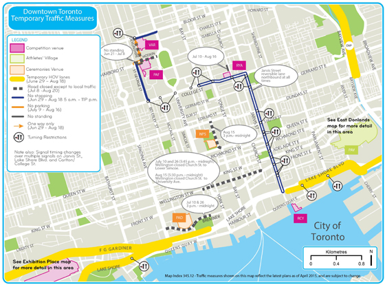
 A map of downtown Toronto traffic patterns, including the area around UHN, planned for the 2015 Pan Am and Parapan Am Games. (Map: Ontario.ca)
It's the largest international multi-sport event Canada has seen – 10,000 athletes and team officials from 41 countries – bigger than Vancouver's 2010 Winter Olympics and the 1976 Montreal Summer Olympics.
So, the Toronto 2015 Pan Am Games, which open one month from today – Friday, July 10 – and run until July 26, is going to impact commuters. Same goes for the Parapan Am Games, which go Aug. 7 to 15.
Temporary traffic measures will make it harder to get around the Greater Toronto Area and the downtown core, including getting to and from UHN sites. The key message is plan ahead, whether coming to an appointment or to visit a patient, or making your way to work.
Here are a few things to keep in mind in getting to and from UHN this summer.
- Traffic is expected to be heavier with road closures and detours in the areas around sporting venues. High Occupancy Vehicle (HOV) lanes on routes in and out of the city will also have an impact.
For the latest traffic updates click
here.
During the Games, transportation planners from across the region will work out of one location to coordinate operations and get information out to the public quickly. That dissemination of information will be through traditional sources such as traffic reports on radio stations and websites.
Links to updated traffic will be posted on UHN.ca and the Corporate intranet site.
- On some of the busiest highways across the Games area, a total of 235 kilometres of HOV lanes will be in operation from June 29 to Aug. 18. This includes stretches of Highways 401, 404 and 427 as well as the Don Valley Parkway, Gardiner Expressway, Queen Elizabeth Way, Lake Shore Blvd. and Jane St. The move is designed to get athletes and officials to and from events quicker and also encourage the public to carpool.
From June 29 to July 27, vehicles must have three or more occupants, up from the typical two. From July 28 to Aug. 18, using the HOV lane requires at least two people in the car.
- Toronto 2015 has adopted a public transit-first plan. Each of the up to 1.4 million spectator tickets being sold also serves as a public transit pass across the GTA for the day of the event.
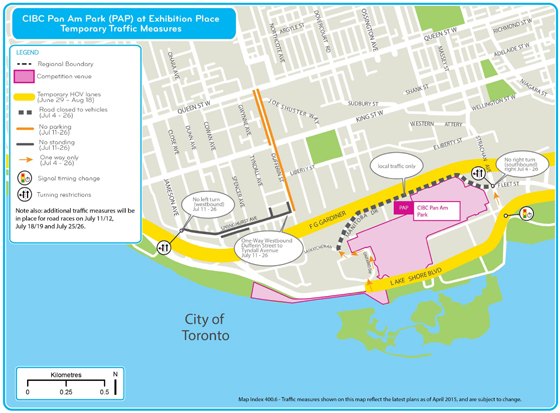 A map of traffic patterns around Exhibition Place during the Games. (Map: Ontario.ca)
With most of those fans expected to be from the GTA and southern Ontario, rather than out-of-province, the TTC and GO Transit are expanding their service during the Games.
The Ontario Ministry of Transportation has also developed a trip planner, which can be accessed
here. This handy tool allows people to put in their starting point and destination to map out their travel across the entire Pan Am/Parapan Am Games footprint, either by public transit or driving. It lists expected time of travel, best routes and the total distance to be covered.
- On Sundays throughout the Games, the subway and all other TTC services will start earlier.
Under normal circumstances, the subway/RT system doesn't begin operations until about 9 a.m. on Sundays. But during the Games, it will begin at about 6 a.m. on Sundays, the same time as the rest of the week. Service levels throughout the system on Sundays will also be operating at Saturday levels.
- In addition to the traffic changes throughout the Games, there will be additional traffic restrictions around Exhibition Place and High Park for road races and other events. The specifics on those events and the resulting traffic implications can be found
here.
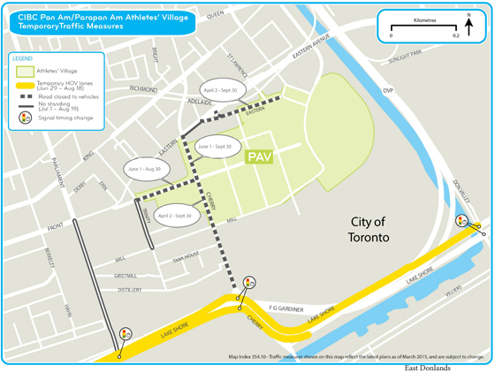 Traffic patterns around the athlete’s village will also change. (Map: Ontario.ca)
